FIS™


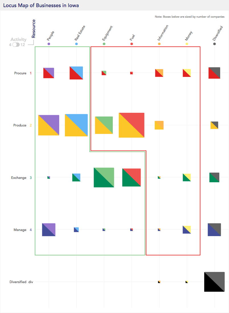
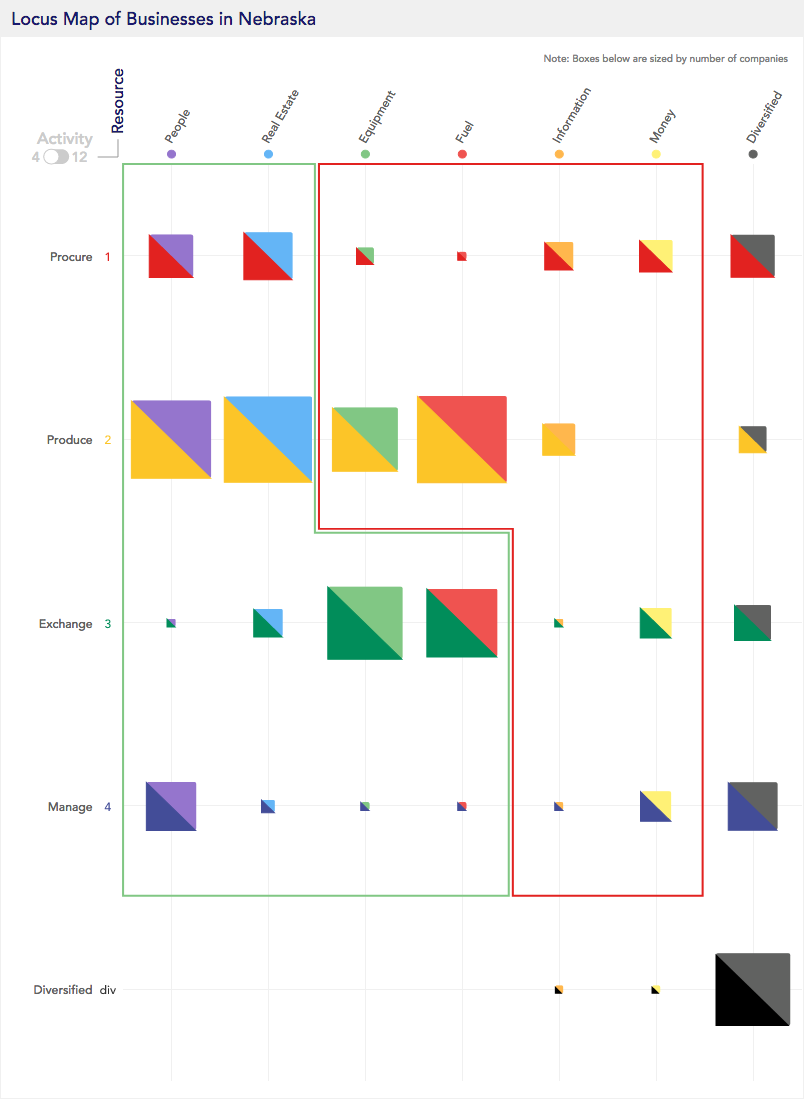
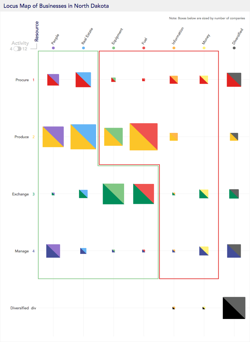
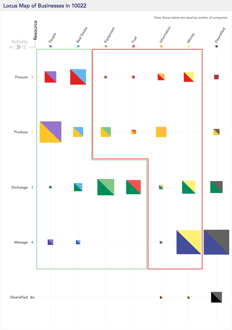
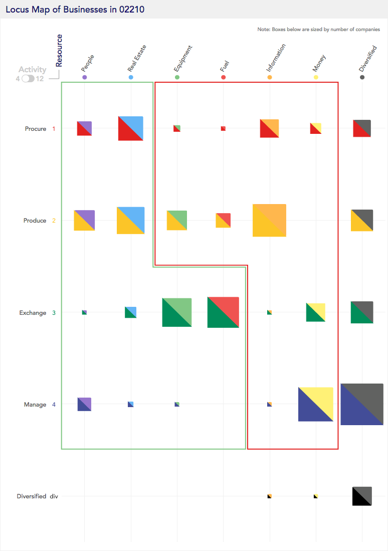
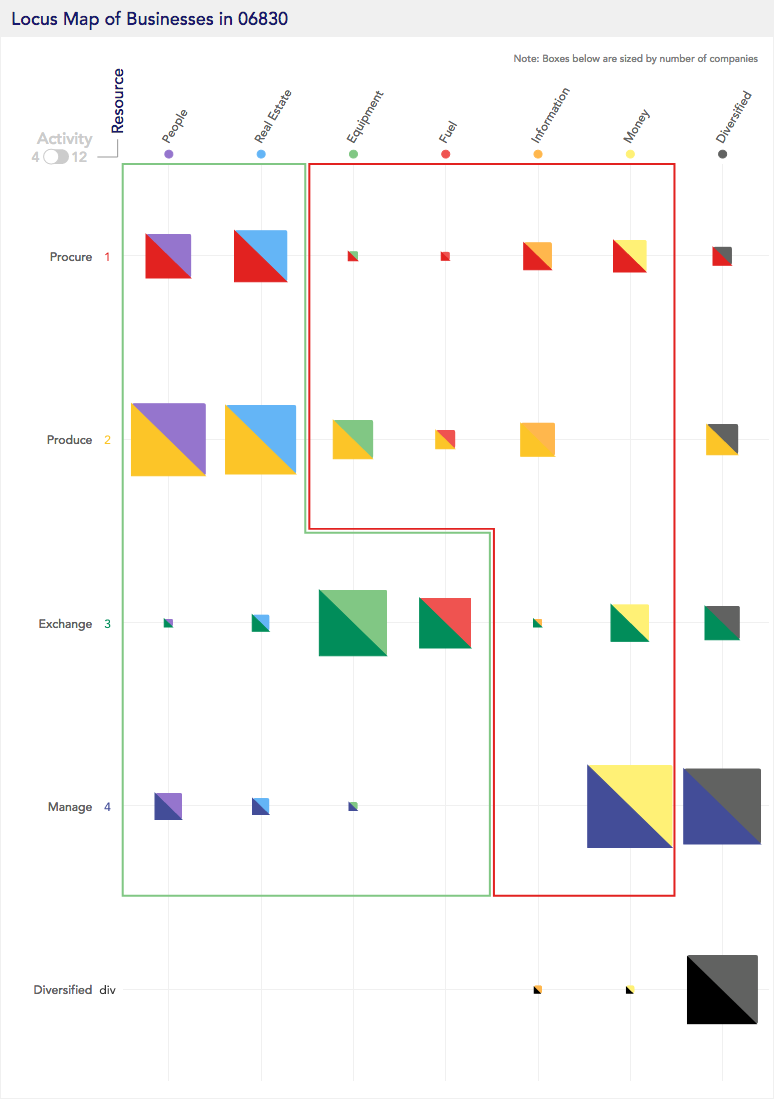
Our FIS tools are a new class of information system for gathering, managing, and analyzing economic data. Rooted in the system sciences, FIS tools organize economic activity into standardized layers of information using the FIS functional coordinate system. FIS relational tools enable users to stitch together, visualize, and analyze information across different types of economic activity using functional attributes as the reference variables. It provides policy makers, asset managers, and even job seekers an entirely new platform for economic inquiry, data analytics, and functional intelligence.

FIS tools use logical data models and unique functional identifiers within a functional coordinate system. Functional identifiers tag defined economic activities with markers, identifying input and output roles within economic systems.

Locus's first FIS database started by functionally mapping businesses, jobs, and products in the United States. It has since been building its global footprint adding FIS-based functional maps of countries as economically diverse as England, China and Mexico.

Our goal is to build the first unified global economic database.


Screenshot-2018-6-1 maps locus(1).png

What is functional intelligence?

Insights derived from understanding the function, organization, and interconnections in the economy.

Functional intelligence begins by identifying components and their roles in an economy, restricting and defining a structured language to describe those parts, and applying that knowledge to structuring data. FIS tools enable functional intelligence by providing a suite of tools that enable users to understand economic data as quantifiable and discrete data points based on universal functional attributes. This is possible because everything from products, job descriptors, business product lines, and industry participants is assigned unique and standardized functional markers in an organized coordinate system. Functional intelligence comes from the insights derived by the user’s ability to search, navigate, and visualize the underlying functional composition, context, and relationships inherent in all economic data.
 
Using FIS tools, users can compare and understand the make-up of businesses, products, and jobs across different economies, times, and geographies.


computer.gif

Functional Search & Navigation


Locate, contextualize, understand.

FIS tools enable users to quickly define, understand, and compare economies across communities using Locus Maps. A Locus Map is a matrix-based visualization developed to efficiently summarize the functional distribution of companies, for instance in geographically defined areas.


Defining Community Typologies

Locus Maps use simple phrases – called loci –  to describe the products of businesses. Just like English sentences, each locus is made up of a verb and an object; for example an agent could “transport people” or “produce equipment.” Locus Maps visualize loci by splitting the verb and object along the axes of a coordinate plane. Placing an economic agent into this coordinate space identifies its functional location in the context of the larger economy.
 
Each box on the grid contains businesses that are functionally similar to each other.


This video illustrates how Locus Maps are derived from the Locus Model. Notice that Volkswagen is located at (2.2, Equipment). This coordinate pair is a Locus and describes the product of manufacturing cars.


While economic activity isn’t distributed evenly across sub-regions, it does tend to cluster in identifiable ways. Because the Locus Maps are standardized, it’s easy to compare one geographic area (a zip code, a city, or a metropolitan area) to another and identify differences in the composition of businesses. Below, we’ll walk you through a few example Maps to show how best to utilize maps.locus to explore and compare economic compositions.


agriculture-cereal-clouds-175389.jpg
 

Agricultural States

Each of these states have a unique functional identifier that represents companies that produce fuel -- over 300% of the national average. This identifier represents companies that produce food or fuel -- think oil, corn, and food crops.

Hover over the locus Maps to see the unique functional identifier


Iowa

Nebraska

North Dakota


aerial-architectural-design-architecture-373912.jpg

Financial Centers

Financial centers are distinguishable by two types of business functions. Similar to business districts, there is a large concentration of lawyers and consultants. Additionally, there is a larger proportion of money service firms like financial advisory, investment management, insurance, and accounting institutions. In the map above, the lawyers and consultants are identified by the blue and grey box; the financial advisors, investment firms and accountants are in the blue-yellow box: the yellow matches them with money.

Hover over the locus Maps to see the unique functional identifier

Mid-town Manhattan

New York, NY (10022)

Boston Waterfront

Boston, MA (02210)

Greenwich, CT

Greenwich, CT (06830)